
Architecture Feasibility Study
An architectural feasibility study investigates and evaluates the potential of a site or building. It is usually designed for the client or clients to inform them on the possibility of a site. It clearly sets out a brief history of the site, its overall condition and significance, as well as the constraints and opportunities. These are further detailed in the flowing sections:
Planning History
Context
Proposal
Cost / Value
[To Download a FREE PDF of this guide scroll to the end]


Planning History
This research is normally done via a desktop study, looking at various websites / the local authority’s website.
The government usually issues The National Planning Policy Framework (NPPF) which sets out a framework for Local Authorities to base their Local Planning Policy.
Below is a list of key areas to consider when conducting this desktop research:
- What local authority does the site belong to?
- Have there been any planning application on the site previously? Approved, Rejected, in progress.
- What does the Local Authority’s Local Plan Policy Map say about any restrictions on the site?
- Are there any further restrictions to building / extending / demolition / alerting structures on the site?
Flood zone https://flood-map-for-planning.service.gov.uk/ – Building in a flood zone can still be allowed, however, further research and a flood risk assessment may need to be completed. This will advise you on how high above the risk zone you can go will need to construct the ground floor and what type of accommodation is allowed on the ground floor.
Area designated for increased development – These sites will usually form part of a wider masterplan by the local authority, allowing for the densification of a site.
Brownfield site / Industrial site – This could mean possible contamination on site or that further research and soil investigations may need to be undertaken.
Listed buildings / Locally listed buildings / scheduled monuments on or near the site https://historicengland.org.uk/listing/the-list/map-search
Protected views https://en.wikipedia.org/wiki/Protected_view
Article 2(3) land – areas such as a Conservation area, area of outstanding natural beauty (AONB), an area specified by the Secretary of State for the purposes of section 41(3) of the Wildlife and Countryside Act 1981 (enhancement and protection of the natural beauty and amenity of the countryside), the Broads, a National Park and World Heritage Sites.
Article 4 Directions – These are specific restrictions on areas designated by the local authority that may restrict permitted development rights, requiring planning permission instead.
Green Belt land – These areas can also be protected under Article 4 Directions or other local policy.
Other area designations – Areas in or near open green areas such as parks, green belt, areas of outstanding natural beauty or agricultural and rural land may have development restrictions as well as industrial and commercial areas that may restrict the conversion to residential or other uses.
Noise map – It can sometimes be useful to look at any neighbouring sound which may restrict the design. Extrium [http://www.extrium.co.uk/noiseviewer.html] provide a map of England showing nuisance sound from roads and rail. For airplane noise, specific neighbouring airport noise maps will have to be consulted, such as the Heathrow flight path noise tracker [https://webtrak.emsbk.com/lhr4]
Other mapping – There can be a huge list of other relevant maps to consult when conducting a feasibility. This can include anything from future tunnel transport locations such as Crossrail 2 [https://cr2.maps.arcgis.com/apps/webappviewer/index.html?id=21a7f72dfd0c443db5733bd81a707a67], historic bomb droppings [http://bombsight.org/#15/51.5050/-0.0900] or how well connected a site is to public transport [https://tfl.gov.uk/info-for/urban-planning-and-construction/planning-with-webcat/webcat].
Are there any significant neighbouring approved applications?
Context
Right to Light – This is an easement in British Law protecting the right of light to existing neighbouring windows. Below are some rules of thumb that are sometimes used in designing massing’s although the only way of knowing if a window is affected by right of light is for a specialist input where they use Waldram Diagrams and apply the accepted ‘50:50 rule’.
[https://www.designingbuildings.co.uk/wiki/Rights_to_light]
Daylight, Sunlight and Overshadowing – Here is it worth bearing in mind if any proposed massing will reduce the daylight and sunlight to neighbouring properties. Below are some rules of thumb used by designers and planners in ascertaining if further expert advice and studies are required.
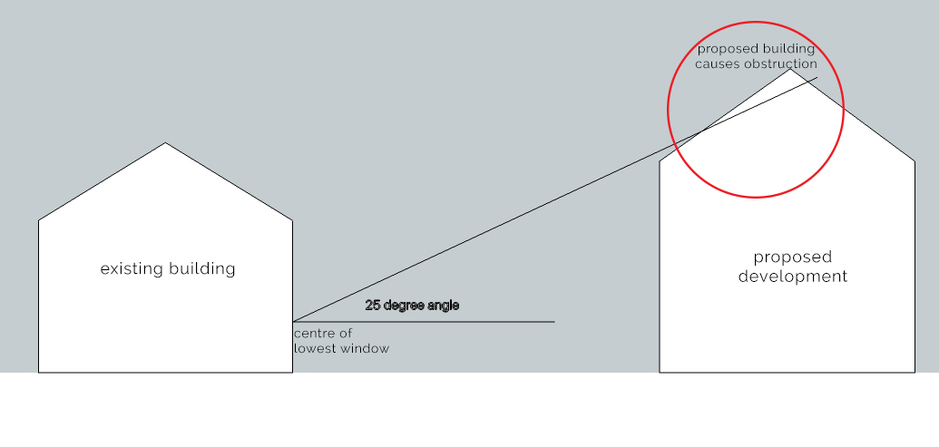
25o rule
A building massing should be no higher that 25o from the centre of the ground floor window.
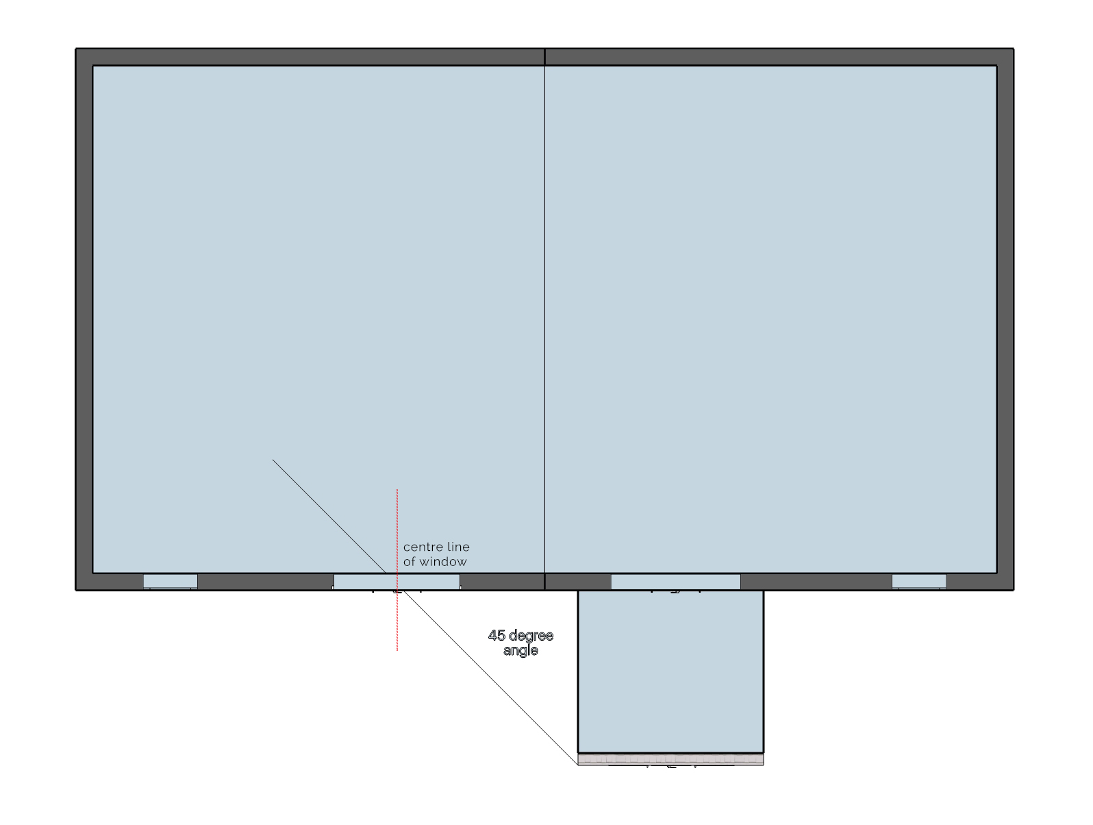
45o rule
If building adjacent to an existing window, you do not want to project the new massing more than 45o from the centre of adjacent windows.
Further information on both of these rules can be found here.
Many of the above rules can be broken with a BRE daylight and sunlight report showing that the interior daylighting is only minimally affected by the development.
Outlook – Many local authorities will also restrict new development within 12m of existing front or rear facades. This is mainly for second floor outlook and not ground floor. This is a rule of thumb, using daylight and sunlight studies or surrounding context can justify reducing this distance. A surveyor that conducts daylight and sunlight reports can be found on an online search engine [https://www.localsurveyorsdirect.co.uk/daylight-reports-sunlight].
Party wall – Whilst it may not be very relevant at this stage of a project, a site with many boundaries and possible party wall issues may take longer to develop and should be flagged to the client as soon as possible. A party wall surveyor can be found using an online search engine [https://www.localbuildingsurveyor.co.uk/party-wall.html] or on the Faculty of Party Wall Surveyor’s register.
Existing Garden – When building within an existing garden, either as an extension, self-contained garden room or an independent unit, the local authority will normally limit development to 50% of the existing garden area. This does not mean that a new unit can be the full 50% of the garden, as the new unit will also require access, outlook and amenity space. For extensions and garden rooms, it is usually acceptable to build over up to 50% of the garden as long as all other permitted development / planning rules are being met.
Proposal
This is an opportunity to look at possible orientation, height and size of proposed massing/s bearing in mind all previous information collected.
This is highly site specific and can be done in a number of ways.
By hand – Some people prefer to sketch over a site plan. This is especially great at the beginning and for a small project. However, if areas of buildings or spaces are key, it can sometimes be difficult to calculate these accurately whilst sketching.
2D CAD – This is a good method when areas are required and the proposal does not have a lot of storeys.
3D CAD – Many designers prefer to work in three-dimensions from the start. This is especially good if a project requires various building heights. Both Sketchup and other more detailed BIM software can be used for block massing.
Combination of the above – Another option is to use a mix of the above.
Some feasibilities will go into great detail, showing internal layouts whilst others may be a simple massing study.
Cost / Value
Sometimes simply called a feasibility, this may be something the client does not require. This can be split into two main sections, the cost of construction and the value of any area/buildings created.
Summary
For More Inspiration…
For More Inspiration…
Resources
Download the Guide
Want to keep this for later? Enter your email below to get instant access to this free download — plus other helpful resources, guides, and updates from the Detail Library to support your projects and professional development.
This form collects information that we will use to send you useful updates from the Detail Library. No spam, no funny business! We will not share or sell your personal information. You can unsubscribe at any time.


Author
Written by Aida Rodriguez-Vega, BA(Hons) MArch DipArch ARB, architect and researcher. At the Detail Library, Aida keeps busy by carrying out technical research and drawing new details for the ever-growing library.
